Israel-Gaza: Why doesn't the region see clearly on Google Maps?
Periskopi (5 years ago)
Why is Gaza, one of the most densely populated countries in the world, a blur on Google Maps? It's a matter talked about by researchers. The use of information is open to the public, including map data, locate attacks, and document destruction. The fact that we don't get high resolution satellite images [...]
It's a matter talked about by researchers. The use of information is open to the public, including map data, locate attacks, and document destruction.
The fact that we don't get high resolution satellite images from Israel and Palestinian territories slows down our” information, says Samir, open source investigator for the BBC.
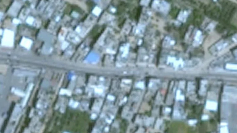
In fact, most of Israel and Palestinian territories appear on Google Earth as low-resolution satellite images. The satellite company has higher quality images available to it. In Gaza City, cars can barely be seen.
If you compare it to Pyongyang, the secret capital of North Korea, where cars are clearly defined and people can be seen.

The Importance of Satellite Images
The use of satellite images has become a vital element in the reporting of conflict, the BBC writes.
Satellites are used by investigators to understand locations of fire, where rockets and collapsed buildings in Gaza and Israel fall.
However, on Google Earth, the latest images from Gaza are low resolution and, therefore, are unclear.
The latest Google Earth image of 2016 is unclear. If I zoom in on a rural area of Syria finds more than 20 images taken since then, with a very high resolution of”, writes Aric Toler, a journalist for Bellingcat.
According to Google, its goal is to keep the regularly upgraded <x0) countries with populated density”, but it was not Gaza's case.
Are high - resolution images available?
Until last year, the US government had imposed a limit on the quality of Israel's satellite images and Palestinian territories, under which American companies were allowed to secure commercially.
This restriction was written in the Kil-Bingaman subx0> amendment, American legislation dating back to 1997, in support of Israeli security concerns.
Under the KBA, U.S. satellite images providers were allowed to offer photos with lower resolution, with a size of pixels no less than 2 million (6f 6), making it an object of the size of a nearly visible but no smaller car.
It is not unusual that countries like military bases are unclear, but the US was the only case that a whole country was subjected to such a restriction.
The Law mentioned only Israel, but it was also applied in Palestinian territories.
So why is Gaza still unclear?
The BBC spoke to Google and Apple (the applications of which also show satellite images).
Apple said she was working to upgrade her maps soon, at a higher resolution of 40cm.
Google said its images come from a series of bidders and he considers “opportunities to update its satellite images, while higher resolution images become available”.
“Taking into account the importance of current events, I see no reason why commercial images in this area should continue to intentionally deteriorate”, said Nick Waters, an open source investigator for Bellingcat on Twitter.