Satellite images show the extent of the devastating earthquake in Croatia: Petrinje fell by 12cm
Periskopi (5 years ago)
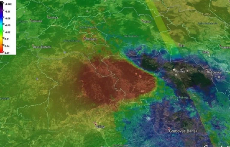
Analysis of satellite radar images from the Sentinel-1 platform is being published on social networks, which further reveal the dramatic nature of earthquakes around Petrinje and Glina in Croatia last days. Oikon Ltd. ) The Institute of Applied Ecology posted records on his Facebook profile, referring to Mladen Viher of the Academy [...]
Analysis of satellite radar images from the Sentinel-1 platform is being published on social networks, which further reveal the dramatic nature of earthquakes around Petrinje and Glina in Croatia last days.
Oikon Ltd. ) The Institute of Efficient Ecology posted records on his Facebook profile, referring to Mladen Viher of the Croatian Military Academy, which shows that Petrinje's wider area dropped by more than 12cm, while the area on the other side of the area, around Gliska Poljana, grew by seven inches.
Sotiris Valkaniotis, an international expert in tectonics and paleosizmology, posted a graphic display of Sentinel-1 data on land slides caused by a 6.2 earthquake in the area on Twitter.
However, it recorded the quake as a size of 6.4, which was recorded in the first moments after the earthquake around Petrinja was recorded by U.S.-based seismological instruments. In another tweet, Valkanoitis posted another graph.
The earth's greatest destruction since the earthquake in Europe since Norway in 2016,” wrote it along with the photo.
He explained there was a rift in the direction from northwest to southeast of Petrinje.
The core appears to have reached the surface (earth), so the surface opening should be able to be found in the fields. ”
Allen Berta posted on Facebook another graphic performance of the same one Oikon Ltd was released. But he added another graph, one that shows the overlapping of the area that was set up with a graphic presentation of injuries in that area.
Andrija Mohorovich, a leading scientist from Croatia, made a discovery regarding the structure of Earth that profoundly affected a number of scientific fields.
So far, we've lived in the belief that the maximum earthquake (in the area) is roughly what happened, size 6.2 or 6.3. This earthquake, which we estimate to be the maximum, is usually calculated to be literally the maximum, to occur extremely rarely, say once every 100,000 years. It is possible to have had an accident and have had that 911 earthquake, he said.
In 1909, however, there was a great earthquake that destroyed chimneys in Zagreb. He had a smaller size, about 5.8, maybe 6, but based on it, Modorovic made his major global discovery: he explained how the Moorovicifiq Fre revealed, otherwise the largest physical object in the solar system by the name of any man.