Weather in Kosovo over weekends and subsequent days
Periskopi (6 years ago)
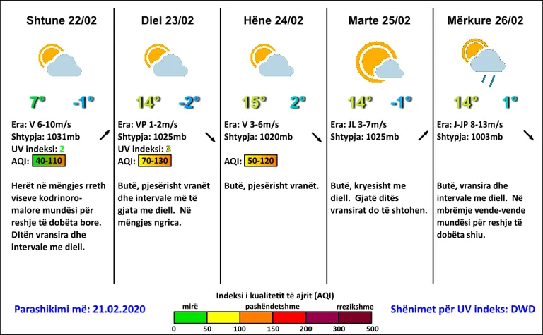
Nighttimes of low snowfall around hillland. From Sunday to Sunday, mild weather with clouds and sunshine. A cold front in weakness is expected to pass east of the region, which over our country in the evening and at night countries can bring conditions for rainfall and snow, surrounding [...]
A cold front in weakening is expected to pass to the east of the region, which over our country in the evening and at night countries can bring conditions for rainfall and snow, around hilly-mountain areas of low snow rainfall, Pristina Weather suggests.
The meteorology service reports that “this cold front will bring fresher air measures, which will easily drop maximum temperatures during Saturday. By Sunday our country will be dominated by high-pressure areas and warm air currents from the Mediterranean, which will increase temperatures significantly above average value”.
According to the PW, “air quality values over the next few days will fluctuate around the average values, and from time to time they will pass into unhealthy values. On Saturday, because of the wind that is expected to blow in the morning, the air quality will also drop to good”.
Forecast on February 22nd-25th:
22,02 Early this morning around hill-mountain areas, access to low snowfall. Clouds and solar intervals.
23,02 Soft, partly killed and sundrums. I froze in the morning.
23,02-24.02 On Monday soft, partly killed. On Tuesday soft, mostly sunny. In the day clouds will increase.
25.02 Bhut, clouds, sun intervals. In the evening places of low rainfall.
The minimum temperatures will vary from -2C to 2C, while the maximum will reach 7C on Saturday, and from Sunday they will mark increased growth of up to 15C.
It's going to blow the average wind and, on average, power from the northern 6.10m/s.
Atmospheric pressure will mark severe growth on normal values, and by the middle of the week it will decline.