3 minutes ago
Estofex warns: In Kosovo, high storm risk
Periskopi(6 hours ago)
(6 hours ago)The European Experient Institute for Projection of the Estofex Storms, which makes nearly daily parachutes for the entire European territory, has shown an extremely unstable atmosphere that could potentially happen today in the Republic of Kosovo.
ESTOFEX (European Storm Forecast Experiement) design harsh weather forecasts by combining human expertise with numeric weather patterns. The process, so simplified, is this:
- Analyse numeric models Like ECMWF, ICON, GFS, AROME and other high-resolution models.
- Assessing atmospheric parameters That favour strong storms, such as:
- CAPE (genus available for conversion),
- Wind Shear,
- Helicity,
- Lefted Index,
- Badness at low and middle levels,
- Strengthening fronts, winding up and upstream.
- Analyzing the Sinoptic Situation to see where the most favorable storm conditions will be created.
- ESTOFEX Meteorologists is not based solely on models; they interpret them based on their own experience and can correct danger areas when they feel that models are wrong.
- Then Publishing risk map to the level:
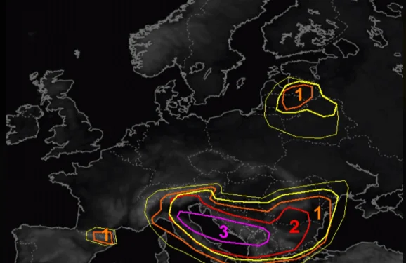
- Level 1 A limited risk of harsh weather.
- Level 2 A considerable risk to strong phenomena (great hail, powerful winds, isolated tornadoes).
- Level 3 A very rare and extremely dangerous situation for harsh weather.
Besides the map, they publish one more meteorological discussion, where they explain the reasons why they have placed each level of danger and what phenomena they expect (in the spirit, destructive winds, tornadoes, intense rainfall, etc.), reports the report. Meteo BalkansPeriscope broadcast.
So, Kosovo today with 21.07.2026 is set to the 3rd highest level of risk that happens extremely rarely, so high care is recommended this afternoon and evening.
Very high-risk air zones have been deployed since a part of the Adriatic Sea in northeast Italy, then the central part of the Adriatic Sea, Croatia's Dalmatia, Montenegro, the South of Bosnia and Herzegovina, Albania's north and Kosovo.
The atmosphere in these areas today is designed to be extremely unstable with potential for very powerful storms, massive hail and enormous proportions, very powerful winds and potential tornadoes. So we're dealing with very high levels of atmospheric instability.
It should be pointed out: These phenomena are perfectly normal during the summer season, even though they are rare at such high levels are completely normal. Almost every summer except heat, there are also severe storms. This has always happened, happens now, and will happen in the future, so there must be caution until the passing and local damage from these storms is inevitable.
Tonight the atmosphere will be extremely destabilised by afternoon and evening hours. This does not mean that storms and great danger will occur 100%, but there is potential in meteorological parameters. Dangerous phenomena if they happen will have local characters, but tonight it's worth increased care. /MeteoBalkan