Satellite images before and after show that parts of Spain have joined the sea after historic rain
Periskopi (2 years ago)
The deadly floods that rocked Spain this week after intense historical rainfall are as broad and severe as from space looks like an internal “ ”. It is known that in just a few hours it rained for a year, creating a flood wave that broke rivers and [...]
It is known that in just a few hours it rained for a year, creating a flood wave that broke rivers ' banks and flooded roads and homes.
At least 155 people were killed by catastrophic floods ] of extreme rainfall events that are becoming very frequent as the world warms up because of fossil fuels pollution, writes CNN
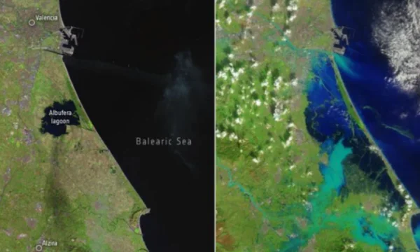
Parts of Spain now look like an extension of the Balatric Sea, as the rains converted what should be dry land into a large water expanse, show satellite images followed by Telegrafi.
Floodwaters manifest themselves as different shades of blue and cover dry soil.

As reported, dramatic and widespread coverage of flooding waters in the interior areas has almost turned coastal areas into islands.
Waterways that were hardly visible in the satellite image “earlier” by the beginning of the month are now highlighted in bright blue, showing how dense they are.
Otherwise, dozens of people have been missing since Thursday as rescue efforts and recovery continue.