First winter weather forecast in parts of the world
Periskopi (2 years ago)
The first forecast for the winter 2024/2025 shows the impact of a poor phase of “La Nina” and a milder polar vortex. La Nina and El Nino show fluctuations in upper water temperatures in the central and eastern Pacific oceans. La Nina is the cold stage of the swing [...]
La Nina and El Nino show fluctuations in upper water temperatures in the central and eastern Pacific oceans.
La Nina is the cold phase of the great and powerful ocean quake. It is a region of the tropical Pacific Ocean that runs through cold, warm stages. The cold ENSO phase is called La Nina, and the warm stage is called El Nino.
As La Nina's arrival, we can analyze how the weather has affected in the past after it was active for several winter seasons, and it transmitsgraphy.
It should be noted that La Nina originated in the Pacific Ocean, so it will not affect weather patterns in Europe as it touches the U.S. or Canada. However, it can mean a more dry trend in the West and more rainfall in the central and eastern parts of Europe.
Seven Weather used seasonal models for early winter forecasts: ECMF from Europe and CanSIPS from Canada.
Models show the average weather conditions during the winter months - the prevailing weather forecast for meteorological winter. So they show how weather patterns 40-60 percent of all wintertimes may look.
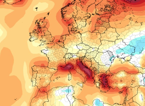
The ECMW model is considered one of the most reliable models for long-term predictions. For the winter, it envisions a high - pressure area extending from the south of the United States across the Atlantic to Western and Central Europe.
As far as temperatures in Europe are concerned, most of the continent will be warmer than normal, due to the impact of a high - pressure system. The forecasting of rainfall points to a worse period in Western Europe, while the rest of the continent expects more rainfall than usual.
The ECMF forecasts an amount of snow below average for the beginning and mid-winter in Europe, that is until February. More than normal snowfalls are predicted over Scandinavian because of the impact of a low - pressure local system.
Canadian model CanSIPS shows La Nina's unlikely poor model and high-pressure area over northwestern Europe. However, these are the first predictions, so it does not yet show areas defined with low pressure, as expected.
Seeing surface temperatures in Europe, the model shows warm abnormalities in most parts of the continent and less rainfall in most of Europe. Less snowfall is expected because of temperatures above normal.
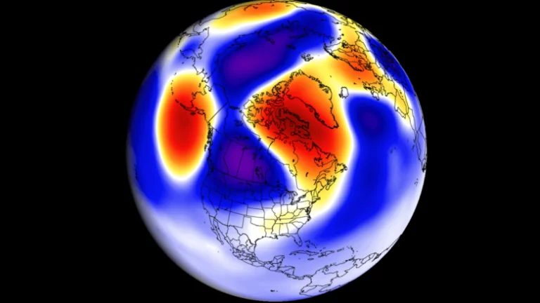
The return of the polar vortex
The polar vortex appears every fall and plays a key role in the development of weather patterns during late autumn, winter and spring. First, though, let us explain exactly what this is about.
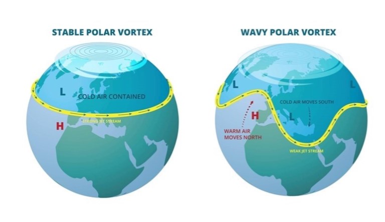
Above earth's poles, both north and south, in higher parts of the atmosphere, the troposphere, and the stratosphere, there are permanent areas with low air pressure called polar vortex, that is, vortex. The polar vortex is more pronounced during the winter months.
The vortex rotates in the opposite direction of clock scorpions with winds of 250 km/h, approximately at the same speed as a hurricane of category 5. A strong polar vortex is usually accompanied by a strong polar circulation blocking the coldest air in polar regions, resulting in softer seasonal conditions for most of the United States and Europe.
On the other hand, a weak polar vortex can make aircraft movement more difficult to hold the cold air that can make its way from polar regions in the United States or Europe. This insight may be inappropriate because there is a significant drop in temperatures in a short period of time.
According to ECMWF models and JMA, we have a force below the average polar vortex at the end of autumn and early winter. This shows more unstable weather patterns and possible interventions of colder air in parts of the United States and Europe.