Dress thick, these are the temperatures that will follow us

Periskopi (6 years ago)
The next cold days, on Friday, the possibility of low snowfall. On weekends, temperatures during the rising gradual day. 5,02,200 Cyclone, which brought cold weather and snowfall, is moving east from the Black Sea. Over our region, future days, high - pressure areas will extend [...]
5,02,200 Cyclone, which brought cold weather and snowfall, is moving east from the Black Sea. Over our region, future days, there will be high pressure fields that will bring mostly clear and sunny weather, especially on weekends.
The snowfalls that fell during the day will continue overnight, and seats tomorrow morning.
On Friday a cold front from the northeast of the continent will penetrate east of the region, and over our country will increase scars, countries and countries expect opportunities for poor snowfall.
In thermal terms, we will remain under the dominance of cold air masses, but daily temperatures will mark gradual growth by weekend.
After improving air quality on Wednesday, with the calming of the winds from Thursday evening, values will be passed to unhealthy, and day-to-day values will swing around the average values.
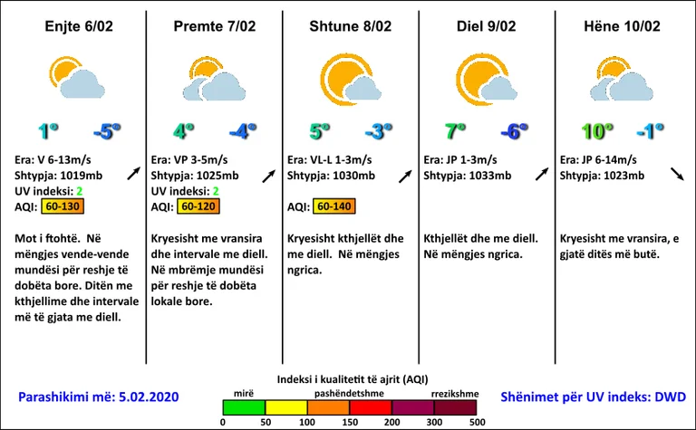
6,02 Cool weather. In the morning, places of low snowfall. Day of clearness and longer solar intervals.
7.02 Mostly with sun and scars. In the evening opportunities for low local snowfall.
8,02-9.02 On weekends mostly sunny weather. Morning hours, I froze.
10,02 Mostly rough, softer day.
On Thursday, temperatures will suffer decline in both extreme values, and then the maximum values will gradually mark growth but remain around average values. Minimals will swing from -6C to -3C, the maximum from 1C to 5C, from Sunday to 7C.
Winds will gradually cease. It will blow mostly from the north wing 6-13m/s, and Sunday, light from southwest 1-3m/s.
Atmospheric pressure will mark rapid growth on normal values. /PristinaWeather/