Rainfall is cut Sunday, weather for the next five days

Periskopi (6 years ago)
Until the weekend of stable weather, no rainfall, in the morning frost. On the softest weekend, our region remains in high - pressure areas, conditioning stable weather, largely clear and cool. On Thursday, colder air measures from the northeast of the continent bring [...]
Our region remains under high-pressure areas that condition stable, largely clear and cool weather. On Thursday, the coldest air measures from the continent's northeast bring temporary cold weather and slight drop in maximum temperatures, Pristina Weather announced.
The meteorology service reports that “from Friday and weekend hot air currents from the Mediterranean will condition mild weather and rise temperatures in both extremes. By Sunday, low - pressure areas from the Atlantic will penetrate from Italy, which is expected to bring possibility for rain, and in mountainous regions over 1,500m of snow”.
According to the PW, weather conditions following days are expected to be more favourable as far as air traffic is concerned, and air quality values will be reduced to average value, but from time to time they will pass into unhealthy ones.
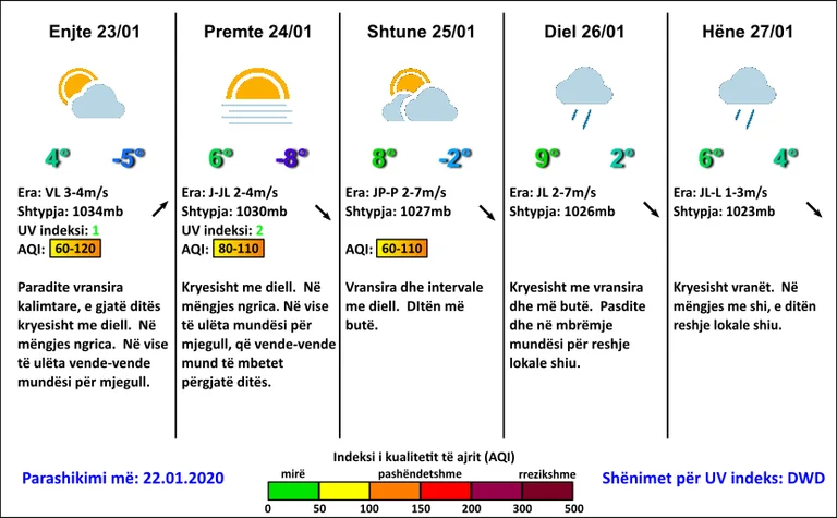
Forecast on January 23rd-27:
23,01 F. In low places the possibilities for fog.
24.01 hours mostly sunny. I froze in the morning. In low places the opportunity for fog, which countries may remain in place throughout the day.
2501-26.01 on Saturday, clouds and sundials, and during the softest day. On Sunday day, mostly with clouds and softer. In the afternoon and in the evening, opportunities for local rainfall.
27.01 percent killed. In the morning rain, and in the day the local rain rains.
Minimum temperatures will fluctuate from -8C to -5C, increasing to +2C at the weekend, while the rising peaks vary from 4C to 9C.
It's going to blow light wind and average different directions 2-7m/s.
Atmospheric pressure will fall, but it remains high above normal values.